
The downhill trails are the main attraction in Spanish Oaks, but there's a lot of very nice riding here. Original trail review and photos April 30, 2020 by Bruce with latest update June 2022.
Spanish Oaks Trail SystemThe Spanish Oaks trails lie in the upper Spanish Oaks recreation area, just south of the mouth
of Spanish Fork Canyon. On this page I am including the paved Dripping Rock Trail (an extension
of the Spanish Fork River trail that connects uphill to the reservoir area and the Hidden Oaks
trails of the Spanish Oaks system).
The Spanish Oaks system, as of May 2020, consists of a uphill-then-DH loop on the eastern and
the western sides, with a small cross-country loop in between. There are older hiking and horse
trails through the area, and these older trails are transected by the newer bike-specific trails.
These older trails won't be of interest to you as a rider, but you'll need to watch for pedestrian
traffic as you cross them.

Looking down toward the reservoir from Spanish Oaks.
 downhill center...")
Dripping Rock trailhead. Underpass (to Spanish Fork River trail ) downhill center. The Dripping Rock trail is straight behind my car.
There are two ways to get to the trails. For a longer ride, I recommend the Dripping Rock trailhead
on Powerhouse Road. The climb to the trail system will be 1.2 miles on paved trail, then 0.3
miles on the gravel continuation. When you reach the Hidden Oaks trail, you can connect to
the rest of the system.
The second access is at the Spanish Oaks reservoir. There's parking where Spanish Oaks Drive
ends at the reservoir, and on the southeast corner of the reservoir off the campground road.
These parking spots provide a more direct access.
Dripping Rock Trail
(access from the north)

Pedaling uphill at the mouth of Spanish Fork Canyon.
The Dripping Rock trail is 1.5 miles long, with the first 1.2 miles paved. From the Dripping
Rock trailhead on the east side of Powerhouse Drive, it extends up the canyon along the Spanish
Fork river for 0.6 easy miles, then turns to climb south to gain elevation.
Find the trail on the east side of the parking area. There are golf cart paths on the south
side, so look for the obvious bike path heading into the canyon. You'll have a gentle slope
following the Spanish Fork River for 0.6 miles.Once the trail turns south to begin climbing, it will gain 350 vertical feet over another 0.9
miles.

Entry to the trail. If it doesn't look like this, it might be a golf path.

Suspension bridge. Not roomy.
The two bridges on the Dripping Rock trail are narrow, particularly the suspension bridge.
You will not be able to pass an oncoming rider without stopping. There simply isn't enough
handlebar room.
Note that in the morning, there's a brisk wind blowing down from the canyon. It's likely that
you'll find it chilly.
When the trail seems to end at a road by the first little reservoir, turn left uphill on sidewalk
for 100 feet and then left on paved trail again. (The path across the road is not open for
riding.)
At mile 1.2, the pavement ends. Continue on uphill, following the main path. You'll go through
a climbing turn shortly after the trail turns to gravel. Then at mile 1.5 the main path turns
right to climb to the reservoir. Look to your left and spot the singletrack Hidden Oaks trail.

Heading downhill.
Hidden Oaks
(climbing to the Spanish Oaks Loop,
Hidden Oaks DH and Campground Connector)

Early in the climb on Hidden Oaks.
The Hidden Oaks trail is bi-directional. This bench-cut runs straight up the left-hand side
of the small canyon, with a fairly taxing rate of climb. It will gain 300 vertical feet in
just over 0.5 miles.
The trail starts on upper Dripping Rock, just as Dripping Rock turns to the right for a final
climb to the reservoir.
After 100 yards, you'll reach a T intersection. To your
right is the exit from the Hidden Oaks DH trail -- a one-way downhill flow trail. Do NOT go there.
Fork left and begin the stiff climb. 1/2 mile later at the top, there will be four trail
options (listed in the order you'll encounter them):
- Right downhill on Hidden Oaks DH
- Right downhill on Campground connector aka Spanish Oaks Flow
- Lower Spanish Oaks Loop keep right
- Upper Spanish Oaks Loop keep left

Almost there as the pitch eases a little. The DH trail is just around this corner.
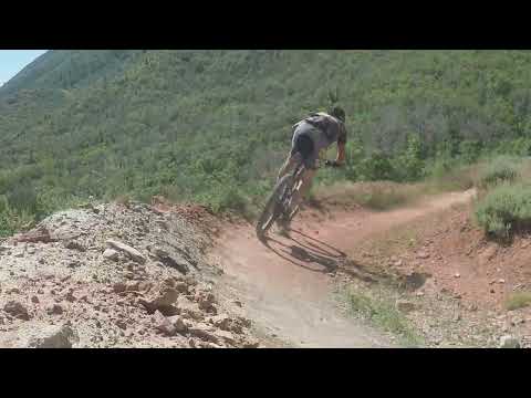
Canyon Run (Hidden Oaks DH)

Bruce rocks the downhill on Hidden Oaks.
Hidden Oaks DH is a 0.5-mile downhill flow trail with substantial machined features. It drops
250 vertical feet. The riding is a constant series of table-tops and highly banked turns. The
features are big and designed for aggressive riding.
While there are many "air" opportunities, the downhill can be done by a good intermediate rider
with wheels on the ground. Beginning riders should absolutely not do this trail, as it requires
speed and a bit of experience to hold the riding line in many of the highly-banked turns. And
if you're riding slow, you might get smashed from uphill.

Whipping around a turn on Hidden Oaks DH.
Campground Connector
aka Spanish Oaks Flow
(Hidden Oaks to the Spanish Oaks campground)

Lots of connected tight turns on upper Spanish Oaks Flow.
The "Spanish Oaks Flow" campground connector trail is a bi-directional trail linking the top
of the Spanish Oaks Campground to the top of Hidden Oaks and the eastern corner of the Spanish
Oaks Loop. If you just came uphill on Hidden Oaks, you'll find the trail on your right about
20 feet past the entry to the Hidden Oaks DH.
If you're arriving from the Spanish Oaks loop (riding northeast) the two sides of the loop
rejoin about 40 feet before this trail forks left downhill.
The Spanish Oaks Flow Trail is 0.2 miles long with 100 feet of elevation loss as it heads from
the Loop down to the campground.

More maple forest. Not much oak up here.

Westbound on the upper side of the loop.
The Spanish Oaks loop is a short (0.8 mile) cross-country type loop. It's shaped like a long
triangle, with the narrow apex at the top of Hidden Oaks. At the western side, the top corner
has a connecting trail over to Lookout Point (and the newer trails being built there) and the
lower corner has a connector over to Rusty Knoll (and a connector to the under-construction
climbing trail there).
The loop is bi-directional. From the trail fork where Hidden Oaks ends at the loop, pick the
uphill (left) option or the downhill option. If you don't plan to ride all the way around the
loop, you might make your choice depending on whether you're heading for the climbing trail
from Rusty Knoll to Lookout Point (go right), or the downhill flow trail that starts on Lookout
Point (go left).

In the middle of the loop the trail traverses fairly steep hillside on both the uphill and downhill sides of the loop.

Breaking out of the trees for a view north to Utah Lake.
The Spanish Oaks Loop is a pleasant but short ride. 90% of the ride is shaded by low maple
forest, but there are occasional breakouts for views over Utah Valley to the west. On the eastbound
side, you'll look at Dominguez Hill (the big cross) and into Spanish Fork Canyon.
A trip around the loop will have a bit less than 100 total feet of climbing.

Eastbound on the lower side of the loop.
Lookout Point Connector
(from upper Spanish
Oaks Loop)

Lookout Point connector trail, riding eastbound away from Lookout Point.
The connector at the upper west corner of the Spanish Oaks loop goes 0.2 miles to Lookout Point.
It has 100 vertical feet of climbing, but it all comes in one ugly grunt in the middle, so
for some of us there's a short bit of push-a-bike.
At Lookout Point, you can take in the views, or descend either the Red Knoll Run bi-directional
trail or the Red Knoll Run DH downhill flow trail to the reservoir area.

Looking north from the Point.
Red Knoll Connector
(lower Spanish Oaks loop to
Red Knoll)

Looking west from the Knoll, just below the radio towers.
At the lower west corner of the Spanish Oaks Loop, a trail traverses 0.2 miles west to the
base of Red Knoll. It crosses the Red Knoll Run DH flow trail just before the Knoll.
There's also a signed route from the lower Spanish Oaks Flow trail (just above the campground)
to Red Knoll. There are quite a few older (and steeper) routes in the area which can be confusing.
I expect signage and navigation to get substantially better in summer 2020 as the system comes
together.
Red Knoll Run
(bi-directional)

Pedaling away from the reservoir early in the climb.
Red Knoll Run is a bi-directional trail that starts low on the campground road, just uphill
from the reservoir parking lot. It extends up to Lookout Point. From the parking lot, it's
one mile long with 350 vertical feet of climbing.
The trail is found by pedaling 200 feet up the campground road from the reservoir parking lot.
Turn to the right onto a wide gravel access road (it goes to the radio towers on Red Knoll),
then quickly split off to the right on the two-way trail.
0.2 miles later, the DH trail joins. Keep to the RIGHT.

View of the climbing route uphill on the Red Knoll Run bi-directional trail. The radio shack and towers are the top of Red Knoll.

As of May 2020, the riding lines on the climb aren't well-established yet. I'm not fond of this trail as a downhill route, but it might get better with tweaking and more riders.
The trail climbs through a series of switchbacks up to the saddle behind Red Knoll, then continues
further up to Lookout Point.
In the saddle at Red Knoll, you can turn left onto the Red Knoll Connector trail to the lower
side of the Spanish Oaks Loop.
At Lookout Point, you have the option of hooking a 180 to drop Red Knoll Run DH, or you can
keep straight and take the Lookout Point Connector trail over to the upper side of the Spanish
Oaks Loop.
Red Knoll Run DH
downhill flow trail (aka Blue Thunder)

Drop-in to the DH at the top of Lookout Point, with the trail curving to the right. The Red Knoll Run climbing route is on the left of the photo.
At the top of Lookout Point, the Red Knoll Run DH trail begins. This is an expert-level downhill-only
flow trail. It drops 300 vertical feet over a 0.7 mile run.
If you arrived via the Lookout Point trail from the Spanish Oaks Loop, it's a straight shot
keeping to the right as you roll north on the ridge.
If you came up via the Red Knoll Run's two-way climbing trail, you'll need to ride past the
entry, then hook a sharp 180.

There's red dirt, white dirt, and brown dirt.

Turns are banked for speed. An advanced-intermediate can handle this trail, but it has an expert rating..
The turns are banked for high speed. There are constant table-top, "double," and step-up jumps.
If you want to do a scouting run before taking any air, these features can all be rolled if
you descend with moderate speed.
The downhill flows well. I didn't consider any of the features to be tricky for a skilled rider.
It was pretty much "aim the bike and let it go."

Bruce rolls the berm on a wide turn.

Handlebar view of a doubletrack heading into Spanish Fork Canyon from Hidden Oaks.
At this time, there's not much that connects to the Spanish Oaks system. At the bottom of Hidden
Oaks, the Dripping Rock trail heads downhill and connects into the
Spanish Fork
River trail
.
The Bonneville Shoreline Trail essentially does not exist in Spanish Fork and Mapleton. There
are some doubletracks that might be future routes, for example, eastbound at the bottom of
Canyon Run (Hidden Oaks). Explore if you must, but these cross private property and have no
developed public access.

Bruce rolls up to Lookout Point on the Red Knoll Run climbing trail.
Bottom Line!
Very fun system. Not a lot of miles, but good riding. Plan on multiple laps.

Map of Spanish Oaks.
Getting there, Dripping Rock trailhead:
In Spanish Fork, take the I-15 exit
for eastbound Highway 6. Continue 4.3 miles until you're about to enter
the canyon. (If you reach the Highway 89 intersection, you went a bit too
far.) Turn right onto Powerhouse Road. On Powerhouse Road as above, drive
0.3 miles from US 6. Note the Spanish Oaks golf parking on your right.
Turn LEFT into the trailhead parking area. Heading up-canyon is the
Dripping Rock paved trail, on the east side of the parking area. This will
be your route uphill to the Spanish Oaks system.
Spanish Oaks Reservoir trailhead: Turn onto Powerhouse Road
as above. Drive 0.8 miles and turn left onto Spanish Oaks Drive. Go 0.6
miles uphill to the Spanish Oaks Reservoir parking. The paved reservoir
parking lot is often full on warm summer days. To reach the dedicated bike
parking, keep straight past the parking lot to the campground road. Drive
200 feet uphill and turn right on a gravel road, then 100 feet later park
on the left side. There's room for 5 or 6 cars here. The uphill trail is
just across and downhill from the gravel parking strip. If you parked at
the reservoir, pedal uphill on the campground road around 200 feet, then turn off the
campground road to the right onto a gravel access road. After 50 feet,
drop to the right at the trail entry sign.
Bathrooms: Spanish Oaks Reservoir, campground
Camping: Spanish Oaks campground


 downhill center...")


