View up the trail as the aspens begin to turn. Plush trail. Photos and ride description by Bruce based on a checkout ride on October 12, 2010. Updated July 23, 2018.
Sardine Peak LoopThe Sardine Peak trail lies north of Snowbasin. The trail itself is 4.3
miles long, but you have to take other trails to get to it, and back from
it. The minimum ride is 7.5 miles. My sample ride below includes an
out-and-back to the
Ogden Canyon Overlook
, which would bring the total to 8.7-miles.
The riding season for Sardine Peak is later June to late October. The top elevation is 7300
feet. While the climb up the Overlook trail can be done by strong beginners, the Sardine Peak
trail is a big harder. I recommend it for early-intermediates or better.

About 2/3 mile into the ride, it's been doubletrack so far. We're looking back toward Snowbasin as singletrack interweaves with the doubletrack.

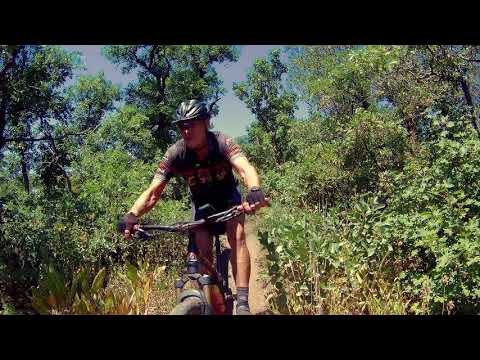
Bruce cruises through aspen forest on the way uphill.
A ride around the 7.5 mile loop requires 1200 vertical feet of climbing. If you make the out-and-back
to the Ogden overlook to bring your ride to 8.7 miles, it's 1500.
My ride description starts at Snowbasin. That's about the right distance and climbing for a
typical rider. You can make the ride longer by picking an alternate trailhead. It's pretty
simple to turn this ride into a 15 mile fun-fest. (See alternate trailheads below.)

Tackling a bit of rough rock on the ridgeline of the Sardine Peak trail eastbound.

At the "official" beginning of the trail at the end of 0.7 miles of gravel road from Snowbasin. You have to pedal to this spot, as the road is routinely closed with a locked gate.
To ride the loop from Snowbasin, start at the overflow parking. That's on the far northeast
corner, past the lodge area. Ride around the metal gate and head gently downhill on gravel
doubletrack. Shortly after the track turns uphill, keep straight as you pass the Maples singletrack
on your right. That's your return path.
A short bit later, singletrack veers off the doubletrack in a meadow. Take either one. They
both wind up at the same place, which is a gate with a trail sign. Go through the gate and
climb through the forest.

The climb up the Ogden Overlook trail is pretty plush. But you can also do the loop counterclockwise if you'd like.

Hitting the ridgeline. An old trail sign lies ahead, and that's Sardine Peak on the right.
At mile 2.1, you'll reach a fork at the top of the ridgeline. If you want to hit the
Ogden Canyon
Overlook
, fork left and head toward the overlook. You'll return to this spot after a round trip of
1.1 miles.
From the trail fork, head east toward the baldish peak. You've got a bit of climbing ahead.
Most of it is pretty smooth. There are a couple of rock outcrops you'll need to navigate. You'll
add about 400 vertical feet as you crank to the east side of Sardine Peak.

Looking south from the ridgeline just west of Sardine Peak, that's Snowbasin in the background.

Looking east toward Sardine Peak. We'll climb to the shoulder of the peak.
You'll run across two trail forks near the peak. The left trail is for hikers. Stay to the
right as the trail forks away and rejoins east of the peak.
For a short time, you're on the north side of the ridge, with an awesome view over Pineview
Reservoir. Unfortunately, the view won't last long, so stop and take a look while you can.

View east over Pineview Reservoir.

How about another photo of Pineview, by drone this time?
Now the trail crosses the ridgeline back to the south side of the hill. Time for some serious
downhill. The trail will zig and zag several times as it sheds elevation.
The trail descends through maple forest, with an occasional stand of fir, aspen, or oak. Control
your speed as you roll the turns -- the soil cuts away easily if you're carving.

The downhill of the clockwise ride flies through a thick forest of maple, with occasional aspen and oak.

Heading gently uphill on the Wheeler Creek trail.
When the trail hits the Wheeler Creek Trail (also known as the Maples Trail) turn right uphill
and climb about 1/2 mile back to the original doubletrack. Turn left toward your car.

Map of the Sardine Peak loop ride.
Riding notes, clockwise, from Snowbasin:
Start at gate, far northeast parking
0.0 Pass gate, enter doubletrack heading north
N41 13.114 W111 51.792
0.6 Keep straight uphill (ST on R is return path)
N41 13.538 W111 51.817
0.7 ST or DT, doesn't matter
0.8 Go through gate N41 13.605 W111 51.894
2.1 Fork L for Ogden / Coldwater Canyon overlook
N41 14.066 W111 52.531
2.7 At overlook N41 14.034 W111 52.801
3.3 Back at fork, keep L N41 14.066 W111 52.531
4.3 Trail in on L, keep straight
N41 14.464 W111 52.071
4.6 Keep R and east, trail in from L
5.0 Cross ridge and begin descent
7.6 Fork R on Maples Trail
N41 13.827 W111 51.510
8.1 Back at DT, fork L
8.7 Back at gate
Getting there, Snowbasin trailhead: From US-89
or I-15 in Ogden, head east on I-84. A few miles up Weber Canyon, take the
Mountain Green exit. As you exit, turn left under the freeway, then right.
Drive a couple of miles through Mountain Green, then turn L on the scenic
byway, U-167. At the top of the hill, turn left and drive to the main
Snowbasin entrance. As you approach the lodges, keep right and descend to
the overflow parking. The trailhead is the gate at the far northeast
corner.<
Alternate, Green Pond: After
turning left off U-167, drive 1.3 miles to a large parking area on the
right. Good ride: down Middle Fork to Maples, up to the loop (in a figure
8) and back via the Green Pond trail. 16.4 miles, 2000 vertical.
Alternate, Art Nord: Head up Ogden Canyon on
U-39. 2.7 miles after the dam, turn R on U-226. Go another 3.6 miles and turn R into the Art Nord
trailhead parking N 41° 14.017' W 111° 49.224'. Recommend big loop ride
with East Fork, Green Pond, Sardine Loop, down Maples. 14 miles, 2500
vertical. Lariat up Maples and around loop, 10.3 miles w 1700 vertical.
Alternate, Middle Fork: About 1.5 miles up the
road from Art Nord, there's a large parking spot on the right. Head north
on Middle Fork to Maples. Lariat or loop as per Green Pond or Art Nord.
Alternate, Wheeler: Heading up Ogden Canyon on
U-39, drop R just before the dam. Follow Wheeler to Maples. Lariat ride or
big loop. Big loop = East Fork to Green Pond to Sardine to Maples, 17.7
miles, 2800 vertical.

Map of Sardine Peak loop
Bathrooms: Art Nord, Snowbasin
Water: Art Nord, Snowbasin
Camping: Pineview Reservoir